


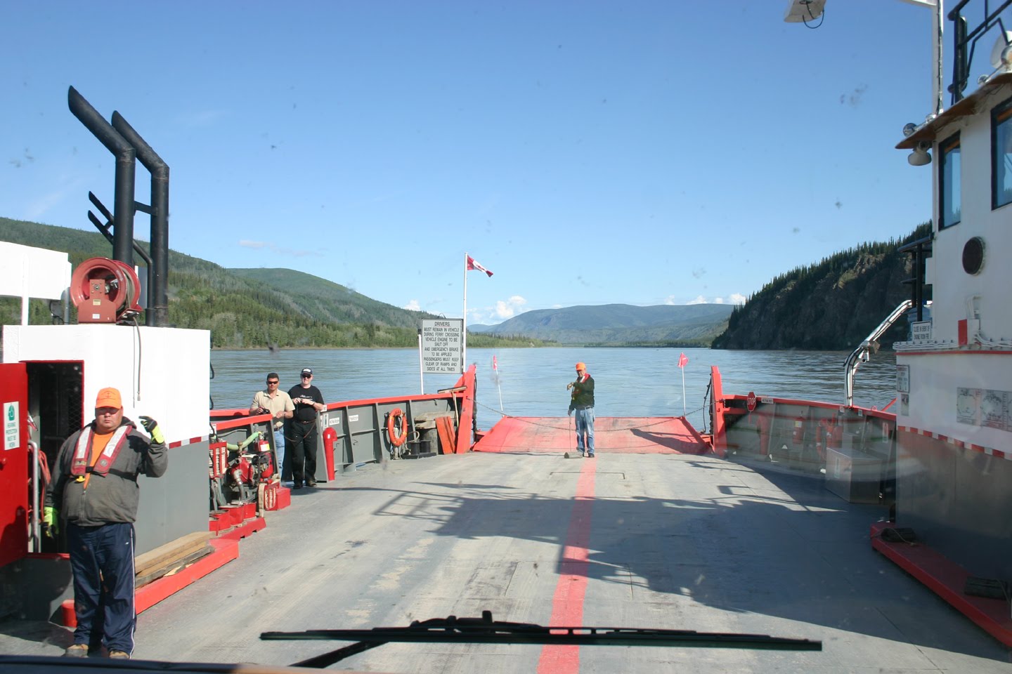


We left Dawson City and headed for Alaska. We started out getting in line for the Dawson City ferry. For you readers not from Whidbey Island, you have to understand that we are frequent ferry users, and think our routine is the only reasonable ferry routine in the world. We normally take ferries that can handle 120 to 150 cars per trip. They dock at large well-engineered permanent docks and have lots of rules and regulations for loading, “disembarking” etc. Well we were in for an experience quite different from our usual. We arrived as the ferry was loading. We got in the RV line which was separate from the cars and trucks. There was a middle line that wasn’t labeled and we could not figure out who went in the middle. One truck drove up just before we were loaded and he got on immediately, leaving behind many in the car line who had been there longer. We were sixth in the RV line. That meant that we had to wait three ferries, because each one took two RVs and about three or four cars. Each crossing took about ten minutes. The landings were gravel, and enormous piles of gravel and a bulldozer were waiting to replenish any of the “dock” that washed away. And this ferry only runs during the spring and summer because the river freezes during the winter and one just drives over the ice. We enjoyed the exposure to a new way.
 Customs in the distance.
 A little closer to customs and the border.
 Small town of Boundary, AK


We headed out over the “Top of the World Highway”. I thought the name came from being far north. Wrong. It really does follow the top of the world. It goes for 65 miles along ridge lines and on mostly gravel roads to the border. The gravel roads were truly better than the paved roads which were full of holes and frost heaves. We were up above the tree line for a lot of the drive. We got to the border in the middle of nowhere. The Customs Officers apparently volunteer for this post and reside at the site from June through August when the road is open. We crossed with no problems.
I had spoken to a woman at Lake Watson tourist information center who told me that though the road was gravel, it was fairly smooth and easy to drive. Well, after crossing the border, we learned that she really only told us about the Canadian side of the road. She didn’t tell us that the Alaskan side was much worse. We did have the opportunity to learn the difference between bumps and dips and we are sooooo thankful for that opportunity. I am sure that you all know what a bump is. A dip is a sudden drop in the road (2 to 3 feet) that if you go over at a speed more than five miles an hour shoves your vertebrae into your teeth and rearranges all the drawers and cupboards in the motor home. It was a long forty more miles into Tok, Alaska. After crossing the border we decided to find a place to pull over by the creek we were following and camp. We found a beautiful spot, and we had seen some people gold mining a couple of miles back so we hauled out the paella pan and pie pan to try a little gold panning. We worked at it for about an hour before a truck pulled up to tell us that we were claim jumping and had to move. He said that he had six miles of the creek as a claim. Mike asked if we could just camp and the man said “I let some people stay but not you”. I guess seeing us with our paella pan in the creek was a little too much for him. (I have to admit, that Mike had scoped out what he was sure was a great spot for gold to be deposited, and as we were getting ready to leave, he stole about a gallon of pay dirt to pan later. Shame on Mike! And shame on him for not finding any gold in that dirt! Maybe it’s the pan!)


We went down the road another ten or so miles to a place beside a larger river. We saw a dredge working there and chose not to endanger our lodging with a little paella panning. Mike was a little nervous about me building a fire, but I promised to put it out before dark! I was sitting by the fire reading at about 10:30 p.m. when I looked up to see a moose cow walking about ten feet away from me. (And she was BIG!) And then a large calf (probably a yearling) followed her. Of course I didn’t have my camera with me then. I grabbed it and tried to follow the pair, but they can move very fast. As I was walking along the small road we were on, a woman with a ten or so year old girl riding in a suv stopped to ask me if I saw the moose. She had heard they were nearby and was hoping that a bull calf she had seen the year before might be one of the moose. Further discussion revealed that she and her husband and child spend June through September/October in Alaska gold mining and then spend the rest of the year in Arizona. She said that we could stay as long as we wanted. They were near the town of Chicken, Ak and she said that the population sign reads 21 and one grumpy old man. ( I must have missed the sign.) She clarified that there are actually 2 grumpy old men and that the miner who kicked us off his claim was one of them.
Today we drove the rest of the challenging road and are resting in Tok, AK. We drove through what we have called the “skinny forest”. It is mostly black spruce which are very thin and not very tall. I also took a picture of a stick forest, which is a skinny forest after it has burned. In Tok, we had three windshield chips repaired and have lollygagged away the afternoon. This evening, the RV park we are in provided live entertainment. A man about our age sang original songs about Alaska accompanied by a violin player who just graduated from high school. In between songs he talked politics. He is very proud of the fact that Tok has no government and no taxes. He is originally from Vermont and had nothing good to say about Vermont or any government. He seems quite happy here, even with the winters. He claims that if your relationship can survive the drive up here, you can survive a winter here together. I don’t think we will try to pass the test.

 Skinny forest
 Stick forest
No comments:
Post a Comment